Hickory Nut Mountain

Hickory Nut Mountain

Hickory Nut Mountain Vista

Spectacular View of Lake Ouachita from the Hickory Nut Mountain Vista

Description:

The Hickory Nut Mountain trail segment begins at the picnic area atop Hickory Nut Mountain and ends at a take-out on FS47A road. The trail follows the south side of the mountain along the top of a rock bluff before dropping onto an old logging road that parallels Hickory Nut Creek. A canopy of old and new growth trees provide shade in the summer heat.

The creek is spring fed and spellbinding as it flows; waterfall after waterfall, cascade after cascade typify the creek as it rushes down the gorge. Look for the Grotto and a four foot waterfall coming off the side of a hill. Large boulders, huge rock outcroppings, and steep drop-offs are common.

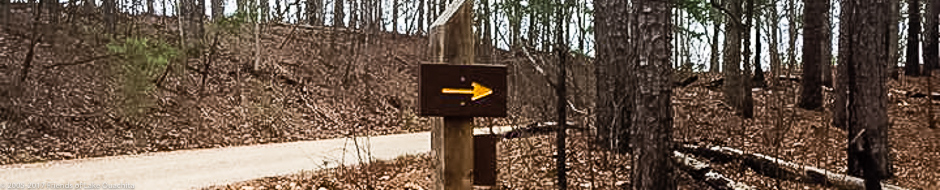
Before embarking on the trail, take note of the sign pointing to the Old Fire Tower spur.  After only a  .15 miles or 10 minutes hike on the spur you will arrive at the old Forest Service fire tower site, which includes the concrete anchors of the tower, the foundation to the fire tower watcher’s cabin, a water cistern, and the two National Geological Survey medallions installed in 1953.

Surrounding Area:

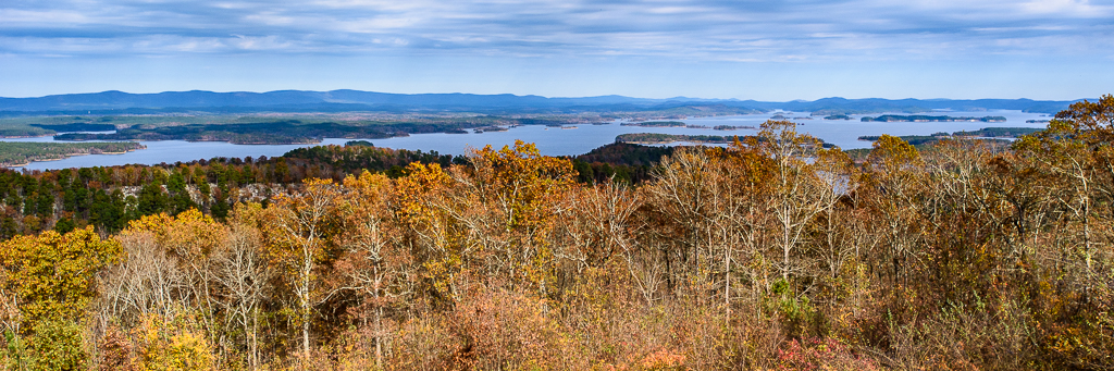
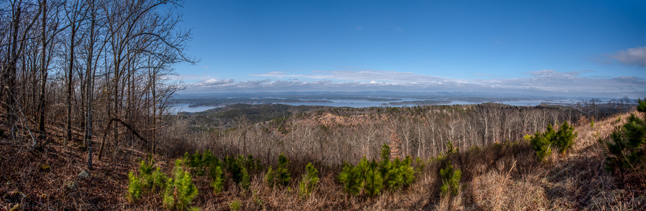
From the picnic area at the trailhead, take a short 1.1 mile hike on the mountaintop access road to the Hickory Nut Mountain Vista where you will see sweeping views on both the western half of the lake and the deep valley south of the Vista. This is the last time you will see the Lake once you start down the mountain.

Length:

3.2 miles one way to the trail termination at FS47A road takeout. But you can also backtrack 4 miles, from the trailhead to P4 Joplin Trailhead.

Difficulty:

The Hickory Nut Mountain trail is largely downhill, sometimes steeply, east to FS47A. But there are seasonal bridgeless creek crossings. The return route is very strenuous and a difficult biking trail. Recommend leaving vehicles at the FS47A takeout..

Amenities:

A primitive bathroom (outhouse style) and picnic tables are available in the day use area at the trailhead.

Directions to Trailhead:

Go east from Mount Ida about 13 miles or west from Hot Springs about 21 miles (a mile or so west of the border separating Montgomery and Garland counties) to Hickory Nut Mountain Road. Turn north (your only option) and travel about 4 miles to the day use area sign at the top of the mountain. This will seem like a long way on a rough road; don’t give up. Turn left through the day use area to the two large cairns, one on each side of the P5 trailhead entrance. Turn right at the day use sign and travel about 1.1 miles to the Hickory Nut Mountain Vista.

To reach the P6 FS47/47A takeout area, go north on Hickory Nut Mountain Road for 9/10s of a mile. Turn right onto FS 47 and go 2.6 miles to the intersection of FS 47 and FS 47A on your left. Go through the gate with an iron post on the right with 47A printed on it. Go 2/10s of a mile to a low water bridge and park just across the bridge. Follow the road to your left for about 500 feet where you will see the trail on your right.

Accommodations:

The trailhead does not accommodate camping. However, the Joplin and Tompkins Bend Trailheads to the west, and Crystal Springs to the east, have campgrounds and resorts nearby.

View of Hickory Nut Mountain from Joplin Campground

View of Hickory Nut Mountain from the Joplin Campground


Recent articles about the LOViT Hickory Nut Mountain Trail Segment:

Hickory Nut Mountain Photo Hike – May 5, 2013

After our “second winter this spring,” we gathered on Hickory Nut Mountain today for a ID & photo hike of the flora on the south slope of the mountain. The second winter had slowed the bloom of the iris and other spring bloomers, but it was a near perfect afternoon for a hike. We had seven hikers for this three mile adventure, again armed with Carl Hunter’s Wild Flowers of Arkansas book and several cameras. After shuttling a vehicle down to the eastern end of this mountainous section, we were off on this really nice downhill hike. Despite the recent rains, the trail was not muddy, and it appeared only a small amount of rain had fallen on the mountain. We did find several old friends blooming along the trail, including the Hairy Spiderwort, Fire Pinks, and Huckleberries laden with blooms. One special find unique in this area was  two blooming … Click to read the full article

Young Hikers on Hickory Nut Mountain – Mar. 18, 2013

Traildogs are often asked, “Why do you build trails?” We answered that question last Monday, as four seasoned Traildogs – Robert & Georgia Cavanaugh and Gail & Jerry Shields – joined Montgomery County’ s 4-H’ers, lead by County Agent Brad McGinly, at the very popular U.S. Forest Day Use recreation area atop Hickory Nut Mountain for a hike on the LOViT Trail and an old fashioned wiener roast. With spring leaf-out still a few weeks away, the views of Lake Ouachita from the picnic area were inspiring to all who attended.  The weather was typical for mid-March, with sunny skies and a light wind, which seemed to further lift the high spirits of the children who were intrigued to be on top of a mountain.  The moms and dads who came along remarked that it been a while since they had visited this popular gathering spot and were pleased to find that … Click to read the full article

Delta State University Hike – Feb. 22, 2013

Traildog Robert Cavanaugh helped a nice group of students from Delta State University in Mississippi and their teacher by providing them with a shuttle and some planning for an overnight hike on the LOViT. The group had originally planned to start Thursday and to spend two nights on the Trail.  However, their trip from Mississippi was delayed due to bad weather, so they were only able to camp a single night. Their trip to Hickory Nut Mountain was greeted by plenty of ice on the trees, a pretty view, but a cold day! … Click to read the full article

Clearing Storm Damage on Section 4 – Jan. 11, 2013

Friday, Jan. 11, 2013, we had five Traildogs working the storm cleanup on Section Four Between the trailhead at Hickory Nut Mountain and Forest Service Road 47A.  It was good to visit this this 3.2 mile section along the southern face of Hickory Nut Mountain again as it is one of the most scenic sections, especially after a rainfall. Hickory Creek that begins on the summit of the mountain was pure eye candy for our team as we cleared downed trees and limbs.  This deep drainage creek creates one waterfall after another as it rushes down the gorge and empties into Lake Ouachita. The area around the artesian spring was highlighted by a set of twin falls just to the north of the spring a sight well worth a hike. We were able to completely clear this section from the Hickory Nut Mt. trailhead to the intersection of U.S. Forest … Click to read the full article

LOViT Marathon – Dec. 8, 2012

A bunch of Traildogs worked the LOViT Marathon this morning. The race is put on yearly by Phil and Bonnie Carr of Shangri-La Resort.  About 70 runners participated this year and enjoyed moderate and overcast weather, perfect for the run. The course begins at the corner of Shangri-La Road and the corner of old Highway 270, proceeds to the Denby Bay Trailhead on the LOViT, and then follows the Trail up to the top of Hickory Nut Mountain, for an out distance of 14+ miles.  The return trip takes the cutoff from the Joplin to Tompkins Bend segment across to the Homestead Trailhead, and then back in, accounting for the remaining 12 miles of the marathon. The ‘Dogs working the various aid stations want to thank Bonnie and Varine Carr for supplying the chili and banana pie.  Very much appreciated! This was a great event, and everyone, runners and Traildogs, … Click to read the full article